Tuesday, June 5, 2007
Misspelling
Apparently I've been spelling Brockway wrong, as in Brockway Summit. I had it in my head as Brockaway. I hate misspellings, so I went back and changed them. Hope I didn't mess anything up...

Monday, June 4, 2007
Second Leg - Brockway Summit to Tahoe Meadows
This leg had a few superlatives: Highest point on the TRT, the leg with the most climbing (I think), and my first solo leg. Brockway Summit, the starting point, is right about 7000 feet, and Relay Peak, about 4 miles from the Tahoe Meadows end of the segment, is over 10,000 (10,338 I think it was.) Add to that that I was alone today, and there was quite a bit more snow around than last week, and it made for a pretty long day.
After I dropped the kids off at school, I drove up and parked my car at the Tahoe Meadows trailhead. (I've always called this Mt. Rose Meadows, but that's not what it's marked as, apparently.) Mich picked me up (she had to visit a jobsite up at the lake anyway) and dropped me off at Brockway Summit, where Chris and I ended last week. Here's the obligatory trailhead sign shot, self-portrait style this time:

Since the first few miles of this segment were uphill again (basically, the access points are all on the passes, so most segments will begin with some degree of uphill) I started out by hiking instead of running. That seems like a pretty good tactic for me - fast-hike the uphills and run the traverses, flats and downhills. When I say fast-hike, I mean pretty quick - if I was, say, walking into the grocery store at that speed, you'd wonder what I was up to... Anyway, here's how the trail started out:

(and by the way, all these photos can be enlarged by clicking on them...)
Came through a meadow of mule ears, and heard a grouse calling right when the guidebook said I would - weird.

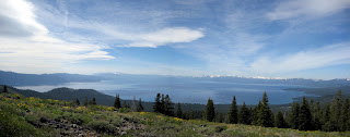
Continuing on, I had some good views of the lake:
There were a couple of funny directions that the trail took at this point, but they were very well marked:

After more great views of the lake, I crossed into Nevada and entered the Mt. Rose Wilderness Area:

At which point the trail became really cool. Basically, I had 2-3 miles where, for the most part, the trail traversed a sidehill. On my left were some interestingly shaped volcanic rocks, and on my right was Lake Tahoe. I could see all of Incline Village, all the way up the east side of the lake. Beautiful. Definitely enlarge this picture, and note the trail leading away on the far left.

And a cheesy picture of me, the trail, and the lake:

It was at this point that I started seeing a few bigger snowdrifts - here's the first BIG one, and one of the few that forced me off the trail:

Most of the snowdrifts I could walk across just fine, but there were 2 or three where they were shaped such that it would have been more dangerous to cross them than to simply go around them. In those cases, i tread as lightly as I could so as not to disturb off the trail, and other than a couple of slips, I think I did pretty well. I one case, this next picture, the snowdrift threw me off of the trail for a few minutes - It disappeared and I had to look around for a little while to figure out where it had gone. Found it, though, and continued on.

Now I came to the last big climb of the day, up the back side of Relay Peak. Pretty big slog up to the top, where I was greeted with a lovely backcountry sight, the radio towers (or whatever they are):

Now I was left with a 4-5 mile downhill to Tahoe Meadows, the start of which you see here:

Partway back, I had to choose whether to take the old way down, which is a gently graded road that allows bike traffic as well, or take the new trail back to the trailhead, which is foot travel only. Since I hadn't seen the new trail yet, I elected to go that way, even though it meant an extra 0.7 miles and another ridge to climb over. Glad I went, or I wouldn't have seen this cool waterfall that Amber blogged about the other day:

So I continued back to the trailhead, where I took the other end shot:

But I still had 0.4 miles to my car, which I had parked at the next trailhead, the start of the Tahoe Meadows to Spooner Summit leg. Don't want anyone to say that I cheesed out by only going from trailhead to trailhead, and not doing the mileage in between. (There is more of that down at the south end of the lake; up to 3 miles between trailheads that are on city streets.) At any rate, trotted down to the car and drank a huge bottle of Gatorade.
I was by myself most of the day - in fact, for the first 16 miles, I saw only one other person. She was doing a look in from Gray Lake, apparently - not sure if she drove in to that or what. In the last 2.5 miles, though, on the new part of the Mt. Rose access trail, I saw about 12 more people.
Numbers:
Trail distance - 19.5 miles
Time on trail: 4:35
Time moving: 4:10
After I dropped the kids off at school, I drove up and parked my car at the Tahoe Meadows trailhead. (I've always called this Mt. Rose Meadows, but that's not what it's marked as, apparently.) Mich picked me up (she had to visit a jobsite up at the lake anyway) and dropped me off at Brockway Summit, where Chris and I ended last week. Here's the obligatory trailhead sign shot, self-portrait style this time:

Since the first few miles of this segment were uphill again (basically, the access points are all on the passes, so most segments will begin with some degree of uphill) I started out by hiking instead of running. That seems like a pretty good tactic for me - fast-hike the uphills and run the traverses, flats and downhills. When I say fast-hike, I mean pretty quick - if I was, say, walking into the grocery store at that speed, you'd wonder what I was up to... Anyway, here's how the trail started out:

(and by the way, all these photos can be enlarged by clicking on them...)
Came through a meadow of mule ears, and heard a grouse calling right when the guidebook said I would - weird.

Continuing on, I had some good views of the lake:

There were a couple of funny directions that the trail took at this point, but they were very well marked:

After more great views of the lake, I crossed into Nevada and entered the Mt. Rose Wilderness Area:

At which point the trail became really cool. Basically, I had 2-3 miles where, for the most part, the trail traversed a sidehill. On my left were some interestingly shaped volcanic rocks, and on my right was Lake Tahoe. I could see all of Incline Village, all the way up the east side of the lake. Beautiful. Definitely enlarge this picture, and note the trail leading away on the far left.

And a cheesy picture of me, the trail, and the lake:

It was at this point that I started seeing a few bigger snowdrifts - here's the first BIG one, and one of the few that forced me off the trail:

Most of the snowdrifts I could walk across just fine, but there were 2 or three where they were shaped such that it would have been more dangerous to cross them than to simply go around them. In those cases, i tread as lightly as I could so as not to disturb off the trail, and other than a couple of slips, I think I did pretty well. I one case, this next picture, the snowdrift threw me off of the trail for a few minutes - It disappeared and I had to look around for a little while to figure out where it had gone. Found it, though, and continued on.

Now I came to the last big climb of the day, up the back side of Relay Peak. Pretty big slog up to the top, where I was greeted with a lovely backcountry sight, the radio towers (or whatever they are):

Now I was left with a 4-5 mile downhill to Tahoe Meadows, the start of which you see here:

Partway back, I had to choose whether to take the old way down, which is a gently graded road that allows bike traffic as well, or take the new trail back to the trailhead, which is foot travel only. Since I hadn't seen the new trail yet, I elected to go that way, even though it meant an extra 0.7 miles and another ridge to climb over. Glad I went, or I wouldn't have seen this cool waterfall that Amber blogged about the other day:

So I continued back to the trailhead, where I took the other end shot:

But I still had 0.4 miles to my car, which I had parked at the next trailhead, the start of the Tahoe Meadows to Spooner Summit leg. Don't want anyone to say that I cheesed out by only going from trailhead to trailhead, and not doing the mileage in between. (There is more of that down at the south end of the lake; up to 3 miles between trailheads that are on city streets.) At any rate, trotted down to the car and drank a huge bottle of Gatorade.
I was by myself most of the day - in fact, for the first 16 miles, I saw only one other person. She was doing a look in from Gray Lake, apparently - not sure if she drove in to that or what. In the last 2.5 miles, though, on the new part of the Mt. Rose access trail, I saw about 12 more people.
Numbers:
Trail distance - 19.5 miles
Time on trail: 4:35
Time moving: 4:10
Sunday, May 27, 2007
First leg - Tahoe City to Brockway Summit
Well - that was just an awesome day. Chris came by just before 7, and we both drove up to Brockway Summit, where we left his car. Shuttled in my car to the Tahoe City trailhead, took a couple of pictures, and were on our way.


The trail from Tahoe City starts with a few miles of pretty good climbing, so we began by hiking instead of running. On top of that, it was pretty rocky, too, as you can see some of here:

But we were rewarded with a few lake views like this:

So we hiked for awhile, until most of the climbing was done, and then did some trail running. Here's a couple more pics of the trail:


It was somewhere in this section that Chris realized that he'd left the keys to his car (which was parked at the other end) in the trunk of my car, back at the trailhead.

Too far in to turn back at that point, so we had to come up with another option. Fortunately, I had brought my phone, and miraculously, it got coverage! Chris called his wife Abby to see if she'd be willing to bring us an extra set of keys...

So we continued running - ran for just over an hour. A few more gratuitous scenery/posing shots:


And finally came to Watson Lake.

Took a little break, had a bite to eat and a stretch, and continued on. I should say: we had been curious if we were going to run into any snow up there. We did, but just a few little patches. Maybe 10 places where the snow crossed the trail, and those ranged from 5-25 feet long. Nothing impassable. Here's one of the bigger ones:

So we basically slogged the rest of the way in. Ran for awhile when it was downhill or flat, but the uphills totally sucked it out of me - don't have my altitude lungs yet. But we made it just fine - a few minutes before Abby showed up, in fact. Here's us waiting:

And my super dirty feet:

Then our heroes showed up with the keys, Abby and Chris's 5-month old Hannah:

From there, we headed down to Kings Beach and took a dunk in a VERY chilly Lake Tahoe (to reduce swelling, Chris says...)

Had a bite to eat in Tahoe City at Rosies, picked up cars and headed home. Great day.
Here are the numbers:
Trail mileage: 19.2 miles
Time on trail: 4:25
Time moving: 4:00
Time running: 2:10


The trail from Tahoe City starts with a few miles of pretty good climbing, so we began by hiking instead of running. On top of that, it was pretty rocky, too, as you can see some of here:

But we were rewarded with a few lake views like this:

So we hiked for awhile, until most of the climbing was done, and then did some trail running. Here's a couple more pics of the trail:


It was somewhere in this section that Chris realized that he'd left the keys to his car (which was parked at the other end) in the trunk of my car, back at the trailhead.

Too far in to turn back at that point, so we had to come up with another option. Fortunately, I had brought my phone, and miraculously, it got coverage! Chris called his wife Abby to see if she'd be willing to bring us an extra set of keys...

So we continued running - ran for just over an hour. A few more gratuitous scenery/posing shots:


And finally came to Watson Lake.

Took a little break, had a bite to eat and a stretch, and continued on. I should say: we had been curious if we were going to run into any snow up there. We did, but just a few little patches. Maybe 10 places where the snow crossed the trail, and those ranged from 5-25 feet long. Nothing impassable. Here's one of the bigger ones:

So we basically slogged the rest of the way in. Ran for awhile when it was downhill or flat, but the uphills totally sucked it out of me - don't have my altitude lungs yet. But we made it just fine - a few minutes before Abby showed up, in fact. Here's us waiting:

And my super dirty feet:

Then our heroes showed up with the keys, Abby and Chris's 5-month old Hannah:

From there, we headed down to Kings Beach and took a dunk in a VERY chilly Lake Tahoe (to reduce swelling, Chris says...)

Had a bite to eat in Tahoe City at Rosies, picked up cars and headed home. Great day.
Here are the numbers:
Trail mileage: 19.2 miles
Time on trail: 4:25
Time moving: 4:00
Time running: 2:10
Saturday, May 26, 2007
First leg planning
Well, it looks like this is going to start sooner than I had thought. Tomorrow I'm going to take a crack at the first leg of the trail, from Tahoe City to Brockway Summit. My co-worker Chris is going to come along; he wanted to do a long run tomorrow anyway, and this sounded like fun. (Not sure if he's going to do the rest of them; he had expressed interest in doing the Mt. Rose to Spooner leg, which is pretty scenic.) Anyway, tomorrow we'll leave pretty early, shuttle cars, and hopefully start on the trail about 7. It's about 19 miles, starts uphill and then is mostly rolling. Should finish before noon. Kind of excited...
Tuesday, May 22, 2007
Joiner
I've been meaning to join the Tahoe Rim Trail Association for a few years now - finally got around to doing it. I've always kind of felt bad that I'm such an enthusiastic user of trails, but can't find the time to get involved in maintenance, trail building, etc. (Coincidentally, one of our friends, Kirsten, recently blogged about her trail-building experience.) So, maybe displaying my official TRT car decal will make me feel better about my lack of participation...

And there it is...

And there it is...
Monday, May 7, 2007
More thoughts
Hmmm - haven't been keeping up on this too well, have I? Just having some more thought about the whole undertaking. Looks like I'm not going to be able to do this on consecutive weekends like I'd hoped - just too much other stuff happening here and there. I'm thinking now that I'll get started as soon as I can, when trails start opening up for the spring, and try to get as much in as I can before schedule conflicts start cropping up. In June and July I'll have Mondays off, so it's possible that I can drop the kids off, then head up and do a segment. Shuttling will be an issue - may have to resort to hitchhiking back to the trailhead. Maybe I'll make a TRT hitchhiking sign. The end of June I'll be in Alaska, so I can do a little more in July after that. In August I start to work Mon-Fri, and the first week in August Mich and I will be going up to Oregon for our birthday/anniversary week. After that, I can start doing Saturday or Sunday hikes as planned to finish it up. Hopefully that will get me in good shape to maybe do the Lake Tahoe Marathon or XTerra race in September...
Friday, April 20, 2007
A Plan
So I had a crazy idea to do the Tahoe Rim Trail this fall. Here's my plan: The whole 164 mile trail can be broken down into 8 sections, ranging from 13 to 32 miles each. (But averaging right around 20 miles.) I would like to do one section each weekend, starting in mid-August and ending in early October. I'll use this blog as a place to do my planning, keep links to thinks I will need, and let people know how I'm progressing. Then, when I actually start doing it, I can post pics and trail descriptions here. Hopefully having this blog will help keep me motivated to go ahead with it...
Subscribe to:
Posts (Atom)