This leg had a few superlatives: Highest point on the TRT, the leg with the most climbing (I think), and my first solo leg. Brockway Summit, the starting point, is right about 7000 feet, and Relay Peak, about 4 miles from the Tahoe Meadows end of the segment, is over 10,000 (10,338 I think it was.) Add to that that I was alone today, and there was quite a bit more snow around than last week, and it made for a pretty long day.
After I dropped the kids off at school, I drove up and parked my car at the Tahoe Meadows trailhead. (I've always called this Mt. Rose Meadows, but that's not what it's marked as, apparently.) Mich picked me up (she had to visit a jobsite up at the lake anyway) and dropped me off at Brockway Summit, where Chris and I ended last week. Here's the obligatory trailhead sign shot, self-portrait style this time:

Since the first few miles of this segment were uphill again (basically, the access points are all on the passes, so most segments will begin with some degree of uphill) I started out by hiking instead of running. That seems like a pretty good tactic for me - fast-hike the uphills and run the traverses, flats and downhills. When I say fast-hike, I mean pretty quick - if I was, say, walking into the grocery store at that speed, you'd wonder what I was up to... Anyway, here's how the trail started out:

(and by the way, all these photos can be enlarged by clicking on them...)
Came through a meadow of mule ears, and heard a grouse calling right when the guidebook said I would - weird.

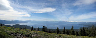
Continuing on, I had some good views of the lake:
There were a couple of funny directions that the trail took at this point, but they were very well marked:

After more great views of the lake, I crossed into Nevada and entered the Mt. Rose Wilderness Area:

At which point the trail became really cool. Basically, I had 2-3 miles where, for the most part, the trail traversed a sidehill. On my left were some interestingly shaped volcanic rocks, and on my right was Lake Tahoe. I could see all of Incline Village, all the way up the east side of the lake. Beautiful. Definitely enlarge this picture, and note the trail leading away on the far left.

And a cheesy picture of me, the trail, and the lake:

It was at this point that I started seeing a few bigger snowdrifts - here's the first BIG one, and one of the few that forced me off the trail:

Most of the snowdrifts I could walk across just fine, but there were 2 or three where they were shaped such that it would have been more dangerous to cross them than to simply go around them. In those cases, i tread as lightly as I could so as not to disturb off the trail, and other than a couple of slips, I think I did pretty well. I one case, this next picture, the snowdrift threw me off of the trail for a few minutes - It disappeared and I had to look around for a little while to figure out where it had gone. Found it, though, and continued on.

Now I came to the last big climb of the day, up the back side of Relay Peak. Pretty big slog up to the top, where I was greeted with a lovely backcountry sight, the radio towers (or whatever they are):

Now I was left with a 4-5 mile downhill to Tahoe Meadows, the start of which you see here:

Partway back, I had to choose whether to take the old way down, which is a gently graded road that allows bike traffic as well, or take the new trail back to the trailhead, which is foot travel only. Since I hadn't seen the new trail yet, I elected to go that way, even though it meant an extra 0.7 miles and another ridge to climb over. Glad I went, or I wouldn't have seen this cool waterfall that
Amber blogged about the other day:

So I continued back to the trailhead, where I took the other end shot:

But I still had 0.4 miles to my car, which I had parked at the next trailhead, the start of the Tahoe Meadows to Spooner Summit leg. Don't want anyone to say that I cheesed out by only going from trailhead to trailhead, and not doing the mileage in between. (There is more of that down at the south end of the lake; up to 3 miles between trailheads that are on city streets.) At any rate, trotted down to the car and drank a huge bottle of Gatorade.
I was by myself most of the day - in fact, for the first 16 miles, I saw only one other person. She was doing a look in from Gray Lake, apparently - not sure if she drove in to that or what. In the last 2.5 miles, though, on the new part of the Mt. Rose access trail, I saw about 12 more people.
Numbers:
Trail distance - 19.5 miles
Time on trail: 4:35
Time moving: 4:10